
There’s a place in southeastern Washington State that’s probably insignificant to nearly everyone who drives by at 60 mph on Highway 730. It’s just north of the Oregon state line at Wallula Gap near the co-mingling of two rivers, the Columbia and the Snake. There’s no marker but the amateur historian in me has stopped here a few times over the years — not just to see the confluence of rivers but to imagine the confluence of centuries as well.
Had I been at this spot at the end of the Ice Age when the suddenly-drained glacial Lake Missoula scoured eastern Washington with the largest floods in the world’s geologic record, I would have seen every drop of that torrent cram its way through the Wallula Gap bottleneck in front of me. A few thousand years later I might have seen the last staggering steps of the fellow now known as Kennewick Man, the most prehistoric skeleton ever found in the United States. 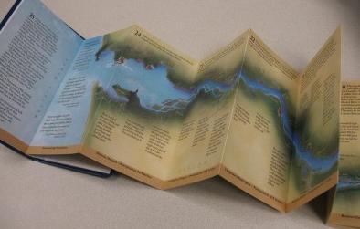 And two hundred years ago, the Lewis and Clark expedition passed through this space. Twice. They were in westbound canoes the first time; on horseback heading east the second. They camped here a total of four days, met with the Walla Wallas, and swam all their horses across the Columbia right over there. It must have been an amazing sight.
I’m mentioning this place because it was on the map in a little book I found called Lewis and Clark: Down and Up the Columbia River [LibraryThing / WorldCat]. I devoured it in one sitting. The unique design is wonderful.
It can fit in a jacket pocket, be read like a normal book one page at a time, or be unfolded into a uncomplicated, double-sided, 7 foot by 6 inch map of the Columbia-Snake river system. Rex Ziak, a gifted local historian and nationally-known L & C expert, marked every expedition campsite in the corridor. He also included short bits of related text, both his own and journal excerpts from the men on the original journey. You can follow the expedition east-to-west and then — by flipping the book upside down — west-to-east.
As an enthusiastic Washington State wanderer, I’ve seen much of this information before and in much more complete formats, but the packaging of this little book is first-rate. If you’re interested in Lewis and Clark from a local perspective with more detail, I’m happy to suggest another book penned by the same author. Ziak wrote an earlier, larger, and well-illustrated book called In Full View [LibraryThing / WorldCat]. I read it five years ago and consider it the best account of Lewis and Clark at the Pacific Ocean, the fulfillment of their mission.
By the way: Lewis and Clark camped the winter at Fort Clatsop in Oregon, but made history in Washington, too. It was on Washington soil that they first saw the ocean and where they engaged in a momentous bit of democracy. Sacagawea, a teen-aged Indian woman, and York, a slave, cast the first votes ever permitted a female or an African-American in our nation’s history.
